Archive for May, 2013

Metrobus H-Line Study Under Way

May 31st, 2013 Comments off

Metro Bus Planning is studying the H lines in the District of Columbia including:

  • Brookland-Potomac Park (H1),
  • Crosstown Line (H2, H3, H4), and
  • Park Road-Brookland Line (H8, H9).

PhotoPhoto1

This is an “emerging corridor”–a corridor which was not included in the original Priority Corridor Network studies–but one with heavy and growing ridership. On an average weekday, 10,000 people ride the H lines; the Sautrday average is 6,300 with 4,500 on Sunday. On-time performance overall for April, 2013 is close to 70%, well below Metro’s goal of 78%. All three lines do meet Metro’s ridership and productivity thresholds. Read more…

Categories: Metrobus Studies Tags:

Final Draft Silver Line Metrorail Map for Review

May 23rd, 2013 63 comments

We are down to the final two!  Based on extensive customer feedback from the latest map revisions, we made some additional improvements to the map:

  • Added the Metro Transit Police phone number;
  • Made the rail lines 24% thinner;
  • Added the Anacostia National Park;
  • Included a note that the map is not to scale;
  • Placed a darkened Silver Line between the Blue and Orange lines; and
  • Lightened the Beltway and jurisdiction borders.

We are now down to selecting the icon to represent a three-line station.  When we asked for feedback in the last round, some of you said that you didn’t like the idea of a completely new, third type of icon on the map (i.e., the capsule).  Others said you liked the capsule, but it was too thin.  It was recommended that we try to make the capsule the same width as the current station dot, but stretch it into an oval.
After reviewing your comments, Lance Wyman went back to his drawing board and came up with these two options:

  • Map #1: Retains the current station dot with thin, white extenders
  • Map #2: Stretches the current station dot into an oval

Take a look at these final versions and let us know which one you prefer. All comments welcome!  Please provide feedback in the comments section below or on our MindMixer site.   Thank you for your input.

full_whiskerfull_pill
Read more…

Categories: Engage Tags: , , ,

North Capitol Street Line (Metrobus 80) Final Public Meeting

May 16th, 2013 Comments off

80 Bus PictureThe final public meeting for the study of Metrobus Route 80 (The North Capitol Street Line) will take place next week!

You’re invited to come see and comment on the draft recommendations for improvements. The study team hopes to submit the final recommendations to the Metro Board this summer for approval.

The meeting is open to the public and will take place on:

Wednesday, May 22, 2013
Anytime between 5:30 pm and 7:00 pm
St. Anthony’s School
12th & Lawrence Streets NE
Cafeteria entrance at 3400 12th Street NE, ground floor

Read more…

BART’s Core Capacity Challenge

May 14th, 2013 2 comments

Regular readers of this site know that Metro is developing a Strategic Plan, Momentum, which makes the case for additional major capital investments we’ll need to accommodate the region’s growth by 2025.  For those of you unfamiliar with the details of Momentum, one of the driving factors behind many of the initiatives is the need for improved core capacity to boost Metro’s ability to carry more riders in the system’s core.

BART System

Read more…

Categories: In The News Tags: , , ,

Southern Ave Station Auto Access “Hotspots”

May 13th, 2013 8 comments

Heat map showing short-distance parking access at Forest Glen station, which will be incorporated into the next rail to bike planning effort (click for full map)

Heat map showing parking access within 1 mile and 3 miles at Southern Ave. station, which may indicate good opportunities for pedestrian and bicycle improvements  (click for full map)

Last December we looked at the Forest Glen station and asked you for insights on why people coming from so close (less than three miles) would drive to the station. In the upcoming weeks we are taking a look at five additional stations that also have a high percent of short-distance parking access and low bicycle use: Southern Ave, Glenmont, Largo Town Center, and Grosvenor-Strathmore. For each, we will explore the station’s local conditions and we ask you to share your insights about what can be done to improve walking and biking access to these stations.

The map on the right (full version) shows auto access “hotspots” around Southern Ave station. The Southern Ave station is located just southeast of the boundary between the District of Columbia and Prince George’s County.

Many residential neighborhoods are located within the three-mile radius of the station, and a large concentration of parking users residing within one mile of the station.

However, many possible barriers could inhibit non-motorized travel to Metro:

  • Southern Ave SE is a fast-moving, four-lane road that is uninviting to pedestrians, despite traffic signals, sidewalks and streetlights.
    • WalkScore.com gives the Southern Ave Metrorail station a walk score of 52 out of a possible 100.
  • The station has no direct connectivity to the surrounding residential neighborhoods.  All access to the station must occur via Southern Ave SE.  As such, many neighbors of the station must travel long and circuitous routes to access Metrorail.  See the image below.
  • The station nestled into a corner of Oxon Run Park, further limiting station access routes for nearby residents.

Read more…

Bike to Metro, and Metro to Work, on Bike-to-Work-Day May 17

May 8th, 2013 2 comments

Bike_to_Metro_and_Metro_to_Work_forweb

Join Metro at pitstops at Cheverly and West Hyattsville Metrorail stations on Bike to Work Day, May 17. Register now for your free T-shirt!

Bike to Work Day is coming soon – and biking to Metro counts too, especially for your free T-Shirt!  If riding all the way to work sounds a little daunting, have no fear. Nearly every Metrorail station has bike racks where you can lock up your bike, and continue your commute by rail.  And every Metrobus has a bike rack on the front with space for your bike, too.

So bike to Metro on Friday May 17 and pick up free stuff, too! There will be over 70 pitstops that morning, including many right near Metro stations.

This year, join Metro for Bike to Work Day pitstops at West Hyattsville and Cheverly stations for:

  • Giveaways and maps
  • Safety and transit tips
  • Bus bike rack demonstration, with a bus on hand

Register now at biketoworkmetrodc.org, and enter pitstop West Hyattsville or Cheverly Metro stations.

West Hyattsville station is directly accessible to the Anacostia Northwest Branch trail and the Sligo Creek trail. Cheverly station has good bike access to the neighborhood of Cheverly to the north, and signs will guide bicyclists from Cheverly Ave. and Columbia Park Rd. We’ll have plenty of bike parking on hand for the day!

More about Bikes and Metro:

Categories: In The News Tags:

Share of Reverse Commute Trips Growing

May 6th, 2013 13 comments

Metro is focused on solving one of the region’s most pressing mobility issues – increasing the capacity of the system to handle more trips through the core (defined below) of the Metrorail system.  While Metro’s planning staff has been conducting technical analyses and searching for the best solutions for some time, we also asked for ideas for increasing core capacity from you as well as discussed the potential for  new lines, new connections and expanding to all 8-car trains during peak periods.

There are also operational strategies Metro could employ to provide more trips on the rail system without expanding capacity.  Among the various options is to promote and encourage more “reverse commuting” where commuters travel opposite the peak travel direction in seats that would otherwise be empty.  Data show that reverse commuting has already increased over the past 10 years and many speculate that it will only increase further as the region builds more suburban town centers near Metro and as Metro begins operations on the Silver Line later this year.
Read more…

Updated Draft Silver Line Metrorail Map for Review

May 2nd, 2013 73 comments

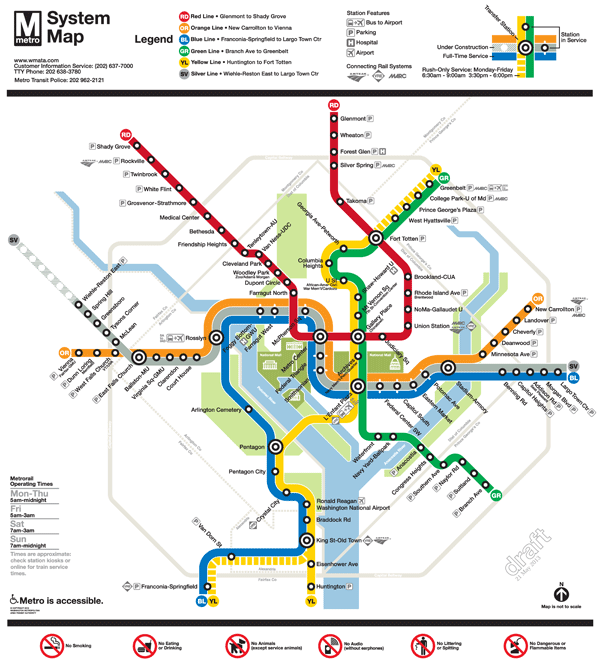
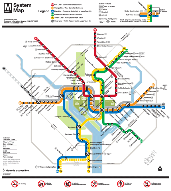
The Silver Line is coming soon, so Metro and original Metrorail map designer Lance Wyman are updating the current map.  Based on extensive customer feedback from the last map revision, we made some general improvements such as making street abbreviations consistent and improving the geographic accuracy of the stations where possible.  Cross streets will remain on the large version of the maps in stations and on trains, where it is most useful for customers as they are traveling on Metro. But in the interest of readability and streamlining, we will keep cross streets off smaller versions of the map often found online and in printed materials.

The first draft of the map (Map 1) also featured 14 percent thinner lines to help readability, now that the Silver Line will travel through DC, and a new station icon with lines that extended across all three rail colors.  This version also included the new Silver Line station names for Phase 1.

When we asked for feedback on the draft earlier this year, here’s what you told us: try even thinner lines, explore other station dot options, and “Center” and “Heights” should not be abbreviated.

So here are two new maps for your review.  In both maps, “Center” and “Heights” are no longer abbreviated.  Map 1 below is an update of the previous draft, with slightly longer “whiskers”.  Map 2 incorporates some additional changes:

  • 24 percent thinner lines, and
  • the use of a capsule-shaped station icon.

Please compare the two maps, visible below, and let us know which one you prefer.

To compare the maps, slide the vertical bar across the image to show the differences between Map 1  and Map 2.  Further below you will find a zoom-in of both maps, also with the vertical slider bar for easy comparison.

All comments welcome!  Please comment below or on our  MindMixer site.  Also, check out Greater Greater Washington’s coverage of the updated map.  Thank you for your input.


2FinalTestMaps-04-29-13-12FinalTestMaps-04-29-13-2


Read more…

Categories: In The News Tags: , ,